PlantKey Open ecological atlas
Planner
Home / Browse / Aleurites / Indian Walnut
iNaturalist — CC, credited & licensed per image
Euphorbiaceae family

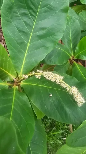
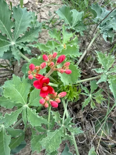
Indian Walnut Aleurites moluccanus

Also known as: Candlenut

Indian Walnut is an introduced plant, found in Hawaii, the lower 48 states, and the Pacific Basin. It grows to 50 ft.

More about this plant

Aleurites moluccanus, commonly known as candlenut, Indian walnut or, in Hawaii, kukui, is a tree in the spurge family Euphorbiaceae. It grows to about 30 m (98 ft) tall and produces drupe fruit. Wikipedia →

⚠ Invasive here — plant a native instead USDA + GBIF

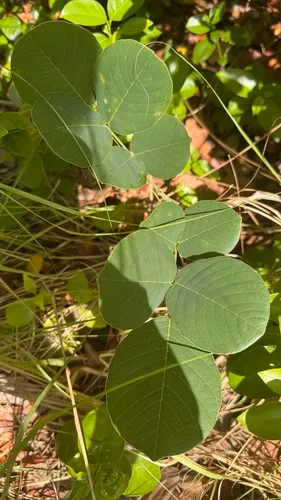
Indian Walnut is flagged invasive in the U.S. These natives fill a similar niche — same growth habit, bloom season, height, and region — so you keep the look and feed local wildlife instead of spreading a problem.

Matched on growth habit · bloom months · mature height · shared U.S. range (USDA + GBIF) — a starting point, not a prescription.

Growing & care

USDA PLANTS · TRY
Conditions
Sources · Conditions
Cold hardiness (derived) — Hardiness
Hardiness
≥ zone 11 derived from its U.S. range
Size & form
Sources · Size & form
TRY Plant Trait Database (CC BY 4.0) — Height · Foliage
Height
50 ft
Foliage
Evergreen broadleaf
In the garden
Canopy layer — Sits in the canopy of a layered food forest or polyculture.Open guide →
Chop-and-drop biomass — Soft, low-density wood is quick-growing and easy to cut back — coppice it and drop the trimmings in place as mulch.Open guide →
derived roles
Species characteristics from USDA PLANTS (public domain) + TRY (CC BY) — general guidance, not a guarantee for your exact site. Deer "browsing" is documented palatability, not a deer-proof claim.

Wildlife & pollinators

How pollinator value is scored →
❧ Caterpillar hosts Documented caterpillar host

Recorded feeding on Aleurites in North America, including:

Named species (a documented Nearctic sample, not exhaustive) from NHM HOSTS (CC0).
Wildlife & visitors 1 bird · 1 mammal

Open records of who else uses Indian Walnut — a generalist food-web signal, kept separate from the keystone Ecological Value.

Recorded eaten by 1 bird and 1 mammal species (fruit, seed, browse):

Interaction records (observations, not exhaustive) from GloBI → (CC0). Counts are distinct species; names are the most-recorded. Common names from Wikidata (CC0).
Species thumbnails re-hosted from iNaturalist — Creative Commons, credited per image (hover for credit). Click any species to see it on iNaturalist. Not exhaustive; many taxa have no openly-licensed photo yet.
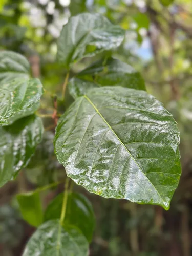
How we know this (2) Methods & honest limits
Leaf build Direct fact

We read each species’ measured specific leaf area (leaf area per unit dry weight) from the Global Spectrum dataset and band it: thin & fast (high SLA), medium, or thick & tough (low SLA). The global median is about 10 mm²/mg.

Honest limits: A species-mean from pooled measurements — individual plants vary with light and site. A broad strategy signal, not a precise per-plant figure.

Díaz, S. et al. (2022) The global spectrum of plant form and function: enhanced species-level trait dataset. Scientific Data 9:755.
Climate niche (heat tolerance & native rainfall) Derived

We take the plant’s U.S. county range and look up each county’s long-term climate, then summarise: native rainfall = the median annual rainfall across its counties; heat tolerance = the warm end (90th percentile) of average temperature across its range (mirroring how our cold-hardiness floor uses an extreme). Counties + medians blunt the roadside/observer bias that makes point-level climate unreliable. Needs at least five placeable counties.

Honest limits: A realized, sampling-biased niche (where it has been recorded, not its physiological optimum), and county climate is coarse — large Western counties span deserts and mountains. Derived guide, never a measured fact.

Realized-niche / climate-envelope approach (Pearson & Dawson 2003; Soberón 2007). Climate: NOAA NCEI nClimDiv county normals (1991–2020).
Derived values are computed from open data by a published method — labelled, cited, and never shown as a direct observation. Full methodology →
Sources for this entry (19) Open & cited
[01] Scientific name & family — USDA PLANTS (DwCA, Zenodo 17903503)
[02] Growth habit & duration — USDA PLANTS (DwCA, Zenodo 17903503)
[03] Native status & distribution — USDA PLANTS (DwCA, Zenodo 17903503)
[04] Common name — USDA PLANTS (via GBIF)
[05] Invasive / introduced status — US-RIIS v2.0 (USGS)
[06] Wetland indicator — USACE National Wetland Plant List (2022)
[08] Description — Wikipedia (CC BY-SA)
[09] Ecological value — GloBI
[12] Functional traits — TRY Plant Trait Database (CC BY 4.0)
[13] Climate niche — Derived — realized climate niche from U.S. county occurrences (GBIF) × NOAA NCEI county climate normals 1991–2020 (public domain)
[14] Cold hardiness (derived) — Derived from U.S. range × USDA PHZM zones
[15] Wildlife & visitors — GloBI — Global Biotic Interactions (CC0)
[17] Other common names — Wikidata (CC0)
[18] Caterpillar species — NHM HOSTS (CC0)
[19] County range — GBIF Open Data — open-licensed occurrences (CC0/CC-BY) → county
Spot an error or have a better photo? Every field links to its source, and the whole dataset is open.
Cite this page Open data, please attribute

PlantKey’s data is open under CC BY-SA 4.0 — free to reuse and adapt, with attribution and the same licence. Photos keep their own per-image licence + credit (see Sources above).

Citation

Loading…

BibTeX
Loading…